AW Aviation Consultancy Services Limited
Radar data consultants.
MSAW and MRVA
AWprojects are specialists in the setup, configuration and optimisation of MSAW and MRVA safety nets. Aircraft approaching an airport usually descend to a level assigned by ATC. The MRVA safety net is a special case of the MSAW alert, alerting if the Minimum Sector Altitude is breached. MSAW safety net will alert if an aircraft is predicted to breach a terrain model.

MSAW
Minimum Safe Altitude Warning.
MSAW uses a terrain model to indicate to controllers whether an aircraft will be in an unsafe trajectory in the very near future.
Terrain models can be generated from DEM files, digital elevation models. The DEM files contain a grid of elevations which we can convert to a suitable native format for Indra Navia (NOVA9000) or Cobham RDS1600 formats.
The AWprojects Visualizr uses DEM data files to provide an effective MSAW alert. Alerts are displayed on the Visualizr display, or an Asterix category 4 data stream can be provided to your RDP for display (provided the radar input contains suitable tracking information).
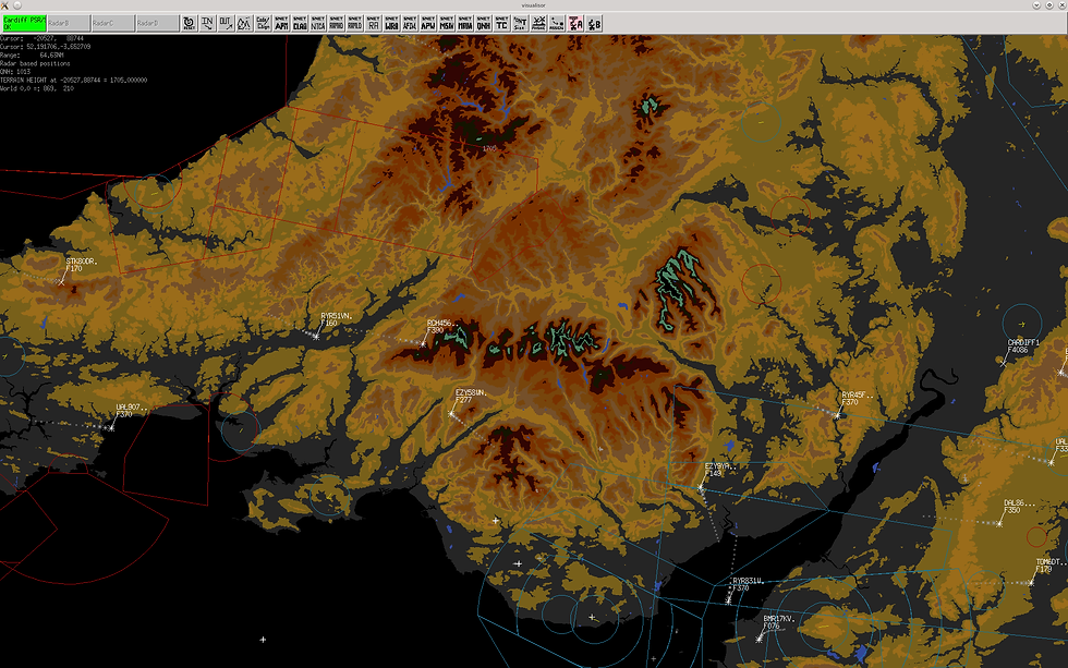
The picture to the left shows the Visualizr product displaying a DEM model from the NASA SRTM mission.

MRVA
Minimum Radar Vectoring Alert.
MRVA is a special case for the MSAW safety net.
If aircraft descend below the radar vectoring altitude an alert will be generated. MRVA may not be provided as a standalone safetynet by the RDP provider. AWprojects can advise and configure the MRVA for both Indra Navia Nova 9000, Thales Eurocat/Topsky and Cobham RDS1600 products.
The AWprojects Visualizr product can provide MRVA alerts as a standalone Asterix category 4 alert using the correct flag settings for this specific alert type. Visualizr also displays MRVA alerts as a standalone alerting system.